About This Project
Understanding subsurface geology is crucial for groundwater, earthquake propagation, and ore studies. Since it’s impossible to dig everywhere and examine the rocks we record variations in their magnetic signal from the surface. The cheapest method is by walking with sensors, but it only covers small sites. Our design records data while riding a bicycle, enabling regional coverage for fewer expenses and exposure of science in practice to people of all ages and backgrounds.
Ask the Scientists
Join The DiscussionWhat is the context of this research?
Mapping of magnetic values is central to understanding the Earth’s subsurface structure. The maps assist water, oil and mineral exploration, and archaeological studies. Regional surveys are expensive, covering hundreds of square kilometers using aircraft. Ground magnetometers are used for localized site surveys only . They are limited by the range a surveyor can cover by walking while carrying the gear (about 10 KMs a day). More expensive solutions fixed the sensors to a non-magnetic cart dragged behind a vehicle and run the cart by remote control or even as autonomous systems (robot/drones). They are also localized. The adventures during such surveys are fascinating, but the stories remain hidden from the public eye, and the data is collected solely for the sake of the survey.
What is the significance of this project?
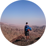
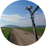
Our simple design scales up the coverage to thousands of square KMs, while using the same equipment and lowering the expenses. We fix the magnetometer sensor components on a polypropylene framework of pipes, anchored to an aluminum-framed hard-tail mountain bike. This provides tough endurance that maintains the sensors at a constant height above ground during the entire survey. The framework is flexible enough to absorb shocks during the off-road and single track riding. The project takes the outreach outside to meet with everyday people and stimulates their curiosity. A flash of excitement from watching science-in-action is as significant as any university classroom, maybe more. By now we covered 3300 square KMs. We met with a wide variety of people from all ages and backgrounds.
What are the goals of the project?
During the past 200 million years the survey region, Galilee, have seen lots of volcanism. Today some of the volcanoes are exposed, but their majority is buried below the surface. Mapping their 3D distribution is critical for accurate calculations of earthquake propagation, and hence assessing the seismic risk to the dense Galilee population. However, this distribution is unknown. Our goals are: (1) to provide the a high-resolution map of these volcanoes; (2) to prove the efficiency and low-cost of the new technique; and (3) to share the enthusiasm and joy of discovery with people of all ages and backgrounds. Instead of inviting them to our lab, we go outside. As geophysicists, the Earth is our lab.
Budget
We ask funding for buying a new, fully operational, bike. This is particularly important while measuring down hills. The maintenance budget will be used for fixing the bike and repairing the framework of pipes holding the sensors. Funds are also needed for the transportation to the field (we do not ask for an accompanying vehicle, accommodation, and the magnetic gear). We would like to print two large posters to be placed on the back of the vehicle and on the bike frame. They will attract the attention of bystanders and stimulate field explanations of science in the process. Finally, we ask for funds for purchasing a software license for the analysis of magnetic data, construction of magnetic maps and running models to calculate the three-dimensional structure of magnetic bodies in the subsurface. These data, the analyses, and interpretations will be released to the public through scientific and popular publications.
Endorsed by
 Project Timeline
By now we have completed measurements across an area of 3300 square km. This is about the size of Rhode Island. With your support we will cover additional 2500 square km. Once we finish this project we would be more than happy to map other regions worldwide and to collaborate.
May 08, 2017
Project Launched
Sep 09, 2017
Complete data collection across the southern Galilee, in 1-2 km spacing between profiles
Nov 04, 2017
Complete data collection across the Hula valley and northwards, in 1-2 km spacing between profiles
Dec 09, 2017
Complete data collection across the coastal plain of northern Israel, in 1-2 km spacing between profiles
Apr 07, 2018
Complete data collection across the northern Galilee, in 1-2 km spacing between profiles
Meet the Team
Affiliates
Team Bio
Our team includes:
Dr. Uri Schattner – rider, developer, geophysicist, University of Haifa
Dr. Amit Segev – geologist, Geological survey of Israel
Dr. Vladimir Lyakhovsky – geophysicist, Geological survey of Israel
Dr. Michael Rybakov – geophysicist, Geophysical survey of Israel
Uri Schattner
Hey, my name is Uri Schattner. Since childhood, I wanted to understand how the Earth works and to become an inventor. I spent most of my childhood outside. In high school I studied physics and math, and in the university I studied both geology and biology during the BSc (Hebrew University, Jerusalem); MSc (applied geodesy) and Ph.D. (tectonics) in geophysics (Tel Aviv University), and then went to two post-docs at the Geological Survey of Israel and the University of Leeds (UK). Later I co-founded the department of Marine Geosciences at the University of Haifa, Israel and was the head of the department for three years. Now I’m a senior lecturer (associate professor). My research focuses on the Earth systems shaping the ocean floor, with a particular focus at the Mediterranean, north and south Atlantic. I investigate the tectonic development of marginal seas and continental margins through geological time; the dynamics of seafloor currents in shaping the morphology of the oceans; and the role of gas systems in the subsurface and seabed. These fascinating studies gave me the opportunity to specialize in marine geology and geophysics, mainly through seismic reflection perspective. I planned and participated in several scientific cruises. I like teaching and especially one-on-one tutoring of MSc and Ph.D. students. After earning my MSc I dedicated two years to teaching children in the desert, translating a sophisticated science into fun content. At the age of 43, I still spend most of my time outside as an avid cyclist and runner.
Project Backers
- 5Backers
- 8%Funded
- $329Total Donations
- $65.80Average Donation