
Please wait...
About This Project

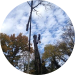
We are exploring the use of drones to collect point cloud data in order to quantify forest fire hazard within the Wildland Urban Interface. The goal is to create an accurate 3-D model of the forest and collect a variety of forest attributes. If successful, this method can be used to assist private land owners and the government to accurately identify areas of high fire hazard in their communities, neighborhoods, and forests.
More Lab Notes From This Project

Browse Other Projects on Experiment
Related Projects
Elucidating the mysterious life of New Zealand eels using environmental DNA methods
Eels are a highly valued fishery, particularly among Māori peoples, and a crucial indicator of...

100%
funded
$5,178
goal
0
lab notes
Helping conservation biologists with 3D glasses for wildlife camera traps
Camera traps photos tell you what animals are in an area, but figuring out how many is tricky. E.g. two...

What is northern Peru's manta and devil ray fishery worth?
This project will contribute to the protection of endangered manta and devil ray species (collectively known...