About This Project
We are exploring the use of drones to collect point cloud data in order to quantify forest fire hazard within the Wildland Urban Interface. The goal is to create an accurate 3-D model of the forest and collect a variety of forest attributes. If successful, this method can be used to assist private land owners and the government to accurately identify areas of high fire hazard in their communities, neighborhoods, and forests.
Ask the Scientists
Join The DiscussionWhat is the context of this research?
In 2015, the United States experienced 51,110 wildfires, burning over 11,000,000 acres. As the drought continues, we expect to see the number and severity of wildfires to continue to rise. Homeowners that live within the Wildland Urban Interface (WUI) are concerned about the devastation these fires can cause to their property; these areas need to be monitored to ensure that communities and homes are protected. Unmanned Aerial Vehicles (UAVs) can be used to measure and monitor these areas for wildfire risk at a lower cost and higher efficiency than ever before. We are using software (link) developed by Carlos Silva, a PhD student at the University of Idaho, to process the data we collect from the UAV-imagery to create 3D models of the forest.
What is the significance of this project?
UAVs have the capability to survey these interfaces more efficiently, at a lower price point, and as frequently as needed. UAVs can survey larger portions of the WUI, or smaller single properties, depending on the needs. The data that will be collected is very similar to LiDAR data which is collected using larger, manned planes.
Through the use of UAVs we will collect aerial data to produce a 3D point cloud of the study area and couple that with on-the-ground tree plot data to provide a complete picture of the canopy model. Our field and model data will be analyzed by a software suite that can assist private landowners to accurately identify areas of high fire hazard in their communities, neighborhoods, and forested parcels in the WUI.
What are the goals of the project?
We have been working with a private landowner in Jackson, WY who owns 44 acres of forested property in the WUI. In 2012, a wildfire came dangerously close to the property prompting the the landowner to become worried about the hazard their forest posed. We have completed most of the aerial survey and have developed an efficient plot design, now we need to install the plots and process the acquired data and have Carlos assess it with his allometric software. We will then have a 3D visualization of the forest and relevant forest attributes that can help us assess fire danger on the forested property.
Budget
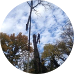
The budget will help reimburse us for our time to collect and process the field and drone data. To analyze our 3D model, we must survey tree plots, which involves collecting a variety of different tree attributes (eg, tree height, canopy height, the trees' diameters, etc.). Collecting accurate plot data is very labor intensive, but it is essential for this project. The budget will also help pay for time already invested in this project.
Endorsed by

Meet the Team
Paul Velte
Paul is the owner and operator of The JH Natural Resource Consultants. He has a BS in Forestry from the University of Vermont, a Graduate Certificate in Geospatial Technologies from Mississippi State and a Master’s degree in Natural Resources from Utah State University. He works as the head forester and arborist for JHNRC.
Paul has been working as a contractor for the Rocky Mountain Research Station for the past two field seasons collecting a variety of forest inventory data for the national FIA program. He has also worked on a variety of FIA projects throughout the pacific northwest. The most applicable project being a forest inventory LiDAR project that was completed in the spring of 2015.
Jason Rolfe
Jason has been gathering geologic field data for over 15 years and has recently been looking at ways to integrate aerial mapping and photogrammetry with other earth sciences. Through the use of unmanned aerial vehicles (UAVs), Jason has created topographic maps, digital elevation models, photomosaics, and 3D models from the acquired aerial data. By combining cutting-edge technologies and untapped research areas, Jason hopes to expand the usefulness of UAVs and explore new areas that they may be used.
Project Backers
- 11Backers
- 30%Funded
- $1,355Total Donations
- $123.23Average Donation