Please wait...
About This Project
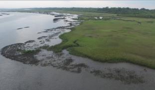
Students within the Jacksonville University School of Aviation are working collaboratively with the Marine Science Research Institute and the Department of Geography and the Environment to use unmanned aircraft systems, or drones, to create orthomosaic maps and 3D models of the oyster reefs in the Northern Jacksonville area. The students will begin mapping in January 2016. The maps and findings will be presented to the backers of this project as well as our partners for further analysis.

Browse Other Projects on Experiment
Related Projects
Out for blood: Hemoparasites in white-tailed deer from the Shenandoah Valley in Northern Virginia
Our research question centers about the prevalence and diversity of hemoparasites that infect ungulate poplulations...
Using eDNA to examine protected California species in streams at Hastings Reserve
Hastings Reserve is home to three streams that provide critical habitat for sensitive native species. Through...
How do polar bears stay healthy on the world's worst diet?
Polar bears survive almost entirely on seal fat. Yet unlike humans who eat high-fat diets, polar bears never...