About This Project
Students within the Jacksonville University School of Aviation are working collaboratively with the Marine Science Research Institute and the Department of Geography and the Environment to use unmanned aircraft systems, or drones, to create orthomosaic maps and 3D models of the oyster reefs in the Northern Jacksonville area. The students will begin mapping in January 2016. The maps and findings will be presented to the backers of this project as well as our partners for further analysis.
Ask the Scientists
Join The DiscussionWhat is the context of this research?
Harvesting of oysters in Northeast Florida was halted when the monitoring stations used to assess the health of the beds were discontinued over 15 years ago. There is growing interest in reopening the beds to commercial and recreational harvesting. Students and professors from the Marine Science Research Institute (MSRI), the School of Aviation, and Geography and the Environment are collaborating to develop a cost-effective method of monitoring the health of oysters reefs in Duval County.
What is the significance of this project?
The use of Unmanned Aircraft Systems (UAS) for monitoring the health of oyster beds in Duval County is a sustainable, cost effective solution. This allows database information to be collected in an efficient and environmentally friendly manner. UAS represent a low carbon footprint solution as compared to manned aircraft; the risk of hazardous waste spill from UAS is low; and the time and resources required to collect the data are significantly reduced. Information gathered through this research will be used to assess changes to the reefs over time and make recommendations to governmental entities about reopening the oyster beds for harvesting.
What are the goals of the project?
The School of Aviation's immediate goal is to engage students operational capabilities utilizing drones to create orthomosaic maps and 3D models with our DJI Inspire 1 drones. Once trained on the mapping and modeling software, the students will begin to map the natural resource area of operation and present findings and reef measurements to our collaborative partners for further analysis. Students will use UAS 3D modeling techniques, which will allow precise measurements to be made of the oyster reefs without creating unwanted damage to the ecosystem. Measurement will be provided to our collaborative partners to assess the rate of growth of the reefs. Students will share their research with our donors periodically and will provide a summary of findings upon project completion.
Budget
The graphics computer will be used primarily for the processing of the imagery taken by the drones to create orthomosaic maps and 3D models. All students engaged in the drone research projects and subsequent applications of 3D modeling techniques at the university will be provided hands on instruction and use of the Pix4D software on this computer.
Endorsed by


Meet the Team
Ross Stephenson
Ross Stephenson is an Assistant Professor of Aeronautics at Jacksonville University where he teaches courses in aviation management. Prior to becoming a professor, Stephenson was a Program Operations Manager for L-3 Communications as well as a pilot with L-3 and Avenge, Inc. His background also includes many positions in the United States Marine Corp where he served as a Master Instructor, Executive Officer, Operations Manager, Director of Flight Operations, and Director of Aviation Safety and Standardization. Ross is currently a student at Embry Riddle Aeronautical University in the PhD in Aviation Program.
Additional Information
Research Operations Area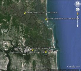
Project Backers
- 12Backers
- 7%Funded
- $261Total Donations
- $21.75Average Donation