38
0
0
Like?
Please wait...
About This Project
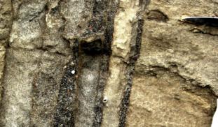
Sheeted clastic dikes offer geologists a new way to count the Missoula floods. The dikes formed coincident with flooding and grew larger with each flood event. Each flood is preserved as one or more fill bands in dikes. Each subbasin preserves a different flood count. Here we test whether clastic dikes grew larger in basins visited by more floods by documenting the number of fill bands in dikes at 300 sites throughout the Columbia Basin.
More Lab Notes From This Project
Browse Other Projects on Experiment
Related Projects
AI analysis of soil pH with a smartphone camera
This project aims to democratize access to soil analysis by developing a machine-learning model to predict...
10,000 years of climate and environmental changes in Jamaica, a biodiverse tropical island
Jamaica is a highly biodiverse island in the Caribbean, but its ecological resources are threatened by climate...
Mapping and dating one of the most important early human settlements in eastern North America
With geophysical techniques, we will search for Paleo-Indian archaeological features around the famed Bull...