


Please wait...
About This Project
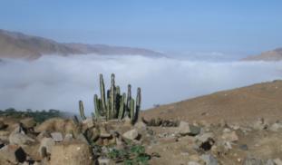
Ampituna is a large, hilltop settlement rumored to be located between the Chancay and Huaura Valleys in Peru. The goal of this study is to find Ampituna and map it using a GPS and balloon imaging. This study is key for understanding how ancient groups moved and interacted between valleys and also will help local peoples gain a better sense of their histories.

Browse Other Projects on Experiment
Related Projects
Unlocking the origins of horse-humans interactions: Radiocarbon dating of ancient horse bits
Horses transformed human history, and horse control technologies evolved over centuries, as demonstrated...
Using community science to evaluate the intersection of social, racial, and economic injustices in North Birmingham, AL
Environmental injustices differentially impact low wealth communities of color, and this pattern of inequity...
How are rural communities on the edge of the largest tropical peat swamp forest in the Congo Basin using peat resources?
Climate change and human interference threaten to degrade the world’s largest tropical peatland. No detailed...