Methods
Summary
Hypotheses, predictions, and objectives
1. Grassland birds, an invasive grass, and arthropods: investigating a potential trophic cascade in an actively managed landscape
The negative effects of habitat loss in grasslands of the Midwest are amplified by invasive exotic grasses, initially planted as cattle forage. We therefore propose to study a rarely tested hypothesis: that invasive grasses reduce arthropod prey available to breeding grassland birds. I will explore this hypothesis for tall fescue, a common exotic grass in our study region, in the context of a landscape-scale fescue removal experiment using herbicide, native seeding, prescribed fire, and alternative grazing regimes. My first objective is to determine if tall fescue affects the grassland bird prey base, and whether this in turn affects grassland bird reproductive success. We expect that as fescue increases, arthropods will decrease and bird diversity, density, and reproductive success will also decrease. My second objective is to determine if herbicide effectively improves bird habitat by increasing arthropod availability, both at the scale of whole pastures and in areas immediately surrounding nests. We expect that on pastures with herbicide, arthropod abundance will increase and avian metrics will also respond positively when compared to controls. This project will add to an existing 10-year dataset on grassland bird abundance in response to habitat management strategies.
2. Exploring restoration potential of private land: how landowner attitudes affect willingness to improve grassland bird habitat
Human behavior is both a driver of species introduction and management to reduce unwanted invasives. However, most research on restoration neglects the study of human behavior. Understanding public willingness to restore habitat is particularly salient in grasslands that hold value for both agricultural producers and wildlife. Using mailed surveys (n=450), we will determine landowner willingness to implement restoration strategies such as invasive control and prescribed fire. We will relate sources of income, demographics, environmental values, and knowledge of the grassland ecosystem to willingness to restore habitat. This will reveal both barriers and opportunities for grassland bird habitat restoration on private land. This project will add to an existing dataset collected a decade ago on how landowner attitudes affect how they manage their land, providing opportunities for longitudinal analysis.
3. Quantifying grassland bird community nest placement through space: understanding fine- and broad-scale characteristics of habitat quality.
Both fine- and broad-scale factors affect nest placement and nest success. I plan to evaluate grassland bird nest-site choices using point process statistics. Point process theory sorts spatial data sets into discrete layers. My focal species are the grasshopper sparrow, dickcissel, and eastern meadowlark because they co-occur on our study sites, have a reasonable sample size of nests, and are of conservation concern. I will compare nest-to-nest layers to explore inter- and intra-specific interactions in nest placement within the avian community of interest, and relate these interactions to fragmentation, a potentially major source of habitat degradation for grassland birds.
4. Evaluating the focal species concept in grasslands: can bobwhite quail serve as a flagship or umbrella species?
Researchers and managers often contend that game species are a useful tool to save habitat for other species because game species are economically valuable to humans. But that assumption has been rarely tested using data in a realistic context. To test this assumption (the so-called flagship or umbrella species concepts), we will compare avian abundance of threatened grassland passerines to abundance of northern bobwhite quailto see if managing habitat for quail positively affects other species. We have chosen the quail as my species of interest because it is often a target of restoration efforts in grassland ecosystems and it is a species that adds economic value to public and privately leased lands through recreational hunting. We will also evaluate landowner attitudes toward northern bobwhite conservation with questions about willingness to change management strategies to benefit quail using the previously mentioned landowner survey (see goal #2). Landowner attitudes will indicate whether bobwhite offer enough incentive to change landowner behavior and encourage voluntary grassland conservation.
Field Methods
Avian surveys: To determine the impact of tall fescue on grassland bird communities, we will utilize bird data collected during the period 2007-2017 during the breeding season. Bird data is collected using line transects in each patch of the study pastures(Pillsbury et al. 2011). Using the same methodology as previous years, we will survey avian communities through the summer of 2017, with the full dataset spanning from 2007-2017.
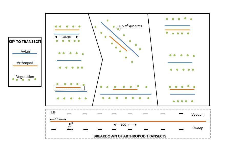
To quantify the avian community present in pastures, transects 100-300 m in length have been placed in each pasture to maximize the amount of grassland habitat surveyed. Depending on size, 3-9 line transects were established in each pasture, with 1-3 line transects per patch. Line transects were used instead of point counts because transects are generally more efficient in open areas(Bibby 2000). Transects were placed at least 150 m apart and at least 50 m from patch edges to minimize double counting or counting birds outside the patch boundary. Universal Transverse Mercator (UTM) coordinates were recorded for the start and end points of each transect, and GPS units have been and will continue to be used for locating transects.
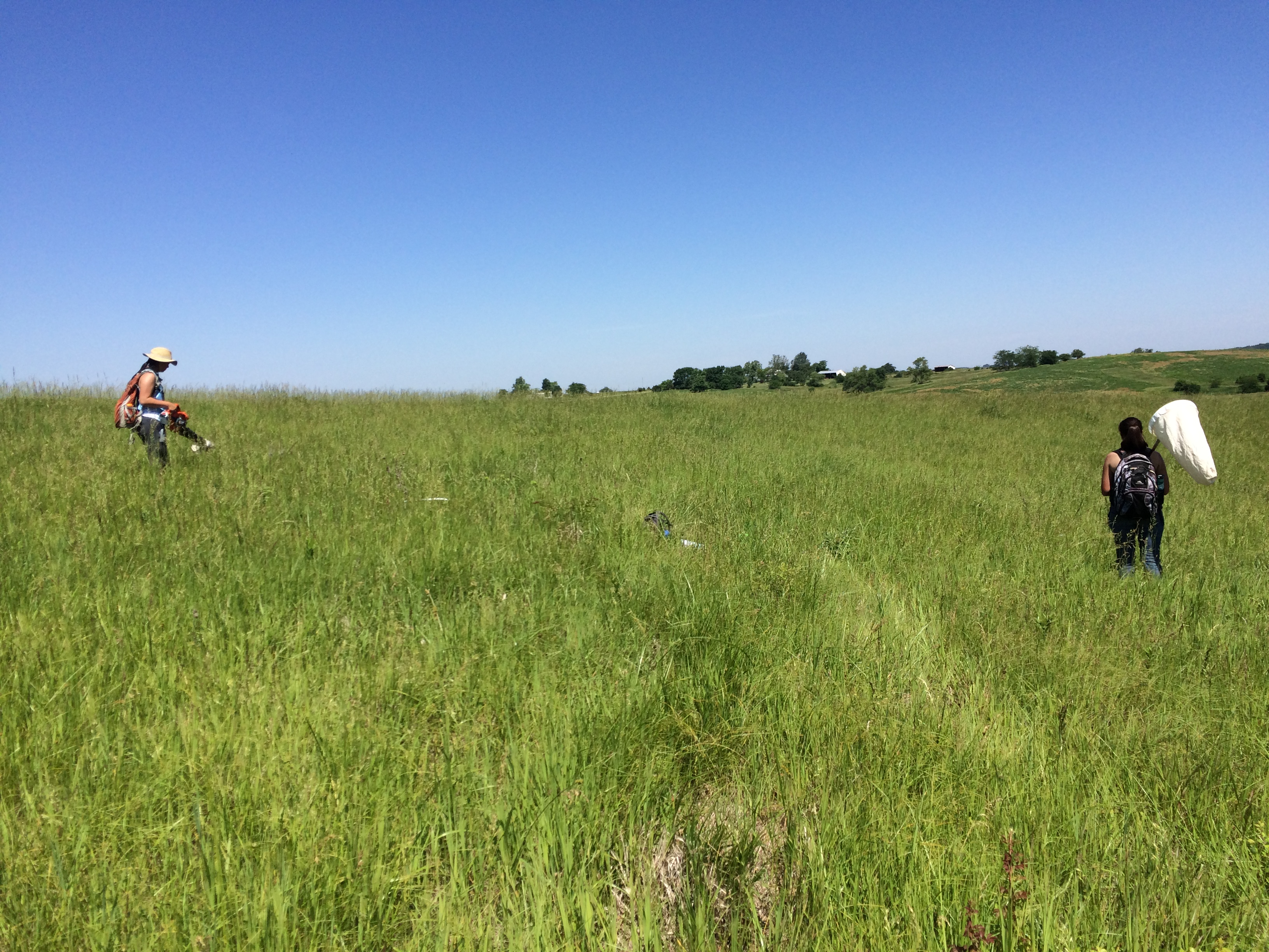
We will survey each pasture five times between 15 May and 10 August. In previous years, pastures were surveyed 5-10 times per summer. Between 05:00 and 10:00 on clear days with winds <10 mph, a trained observer will walk the transects recording all birds seen and/or heard within 50 m. The observer will note species, group size, distance from transect, angle from observer (0-180 degrees), and sex when possible. Distances will be determined using a rangefinder, and angles will be determined using a compass. Observers will be trained and tested on field identification, and will be rotated to randomize potential bias.
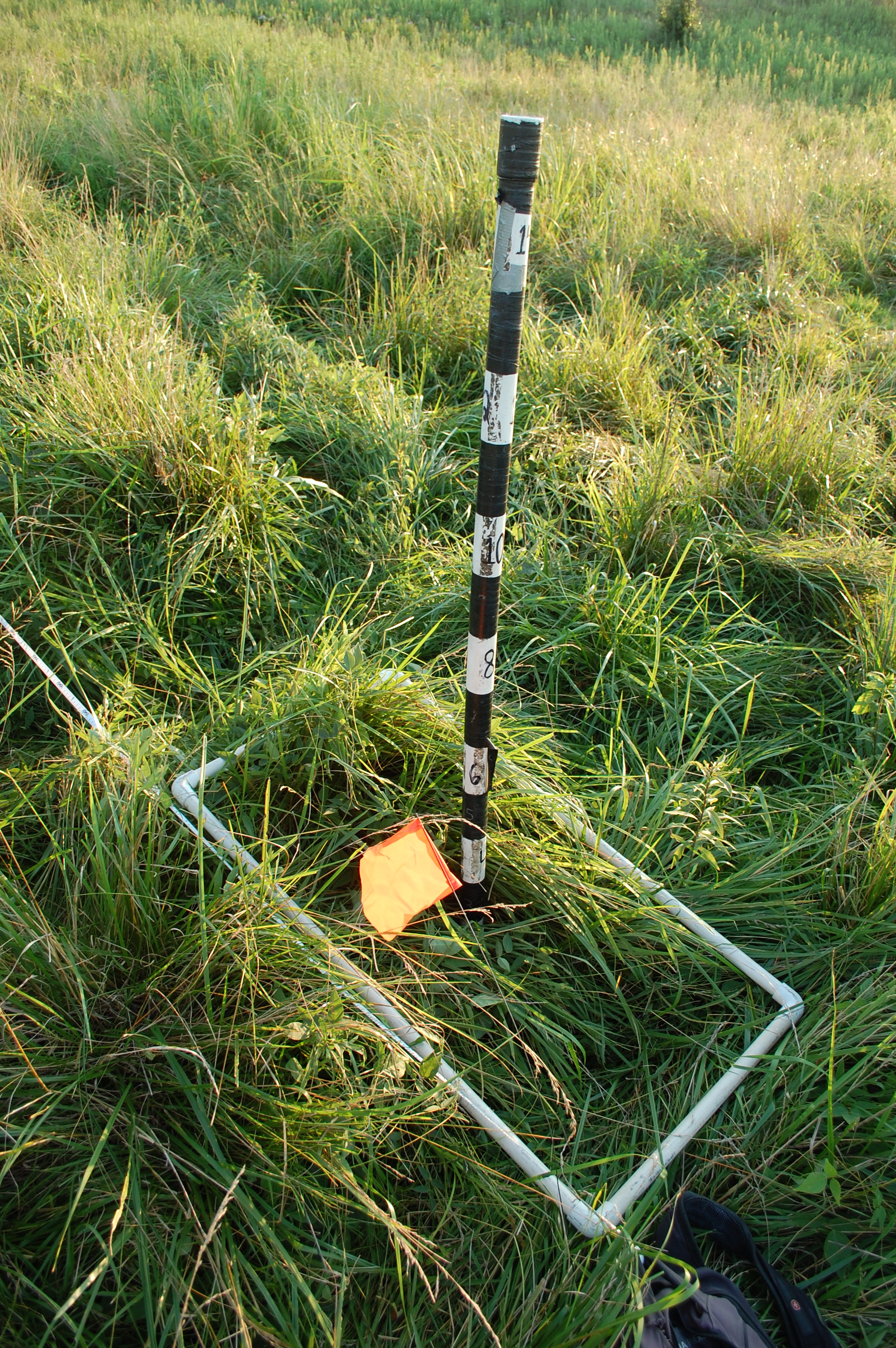
Vegetation Sampling:To assess relationships between fescue and avian communities, we will measure the composition and structure of vegetation every July. To accomplish this, we will use 90 0.5-m2 quadrats (30 sampling points per patch) to ensure even sampling of all pastures. These sampling points are located parallel to avian transects at a distance of 25 m on either side (Daubenmire 1959). Within each quadrat, we will measure visual obstruction (Robel et al. 1970)and will visually measure percent cover of tall fescue, warm-season grasses, cool-season grasses, forbs, legumes, woody species, leaf litter, and bare ground. Percent cover will be recorded as the midpoint of the following categories: 0, 1-5, 5-25, 25-50, 50-75, 75-95, and 95-100 (Daubenmire 1959). For visual obstruction, a Robel pole will be placed at the center of each quadrat, and the observer will record the highest point (at 1-dm intervals) at which the pole is obscured by vegetation at least 50% from a distance of 4 m in each cardinal direction. Identical data have already been collected on the study pastures using this same method from 2007-2015.
Arthropod Collection: To determine the impact of tall fescue on arthropods, we will use a modified leaf blower (Wilson et al. 1993)and sweep net. Vacuuming can under-sample foliar and flying arthropods, and sweeping often under-samples ground-dwelling (Stewart and Wright 1995; Buffington and Redak 1998; McIntyre and Thompson 2003). Using both will allow control for these biases. We will place six 100-m line transects in each pasture, each 20-m to the side of avian transects we will collect arthropods twice per summer 2015-2017, once mid- June and once mid-July, randomly assigning sampling order.
Sweeping and vacuuming along these transects will be completed simultaneously 5 m to either side of the transect, sides assigned randomly. The vacuum will be moved side-to-side in a 1-m swath along these transects while being held 8-20 cm off the ground. The net will also be swept 10 times per sub-transect. Because sampling in grasslands often results in a large volume of specimens, I developed a sub-sampling transect method that allows large distances to be covered without over-sampling. Each 100-m transect will be sub-sampled, with 2 m out of every 10 m vacuumed or swept. This amounts to 20 m sampled per 100-m transect.
After sampling, arthropods will be transferred to freezer bags, preserved in 70% ethanol, and stored at room temperature until processing. Samples will be cleaned by removing vegetation and other debris in the lab, identified by trained observers under a dissecting microscope, and transferred for storage in centrifuge tubes with 70% ethanol. Arthropods will be identified to order, focusing on orders most commonly eaten by breeding grassland birds, including aranea, coleoptera, orthoptera, and lepidoptera (McIntyre and Thompson 2003).
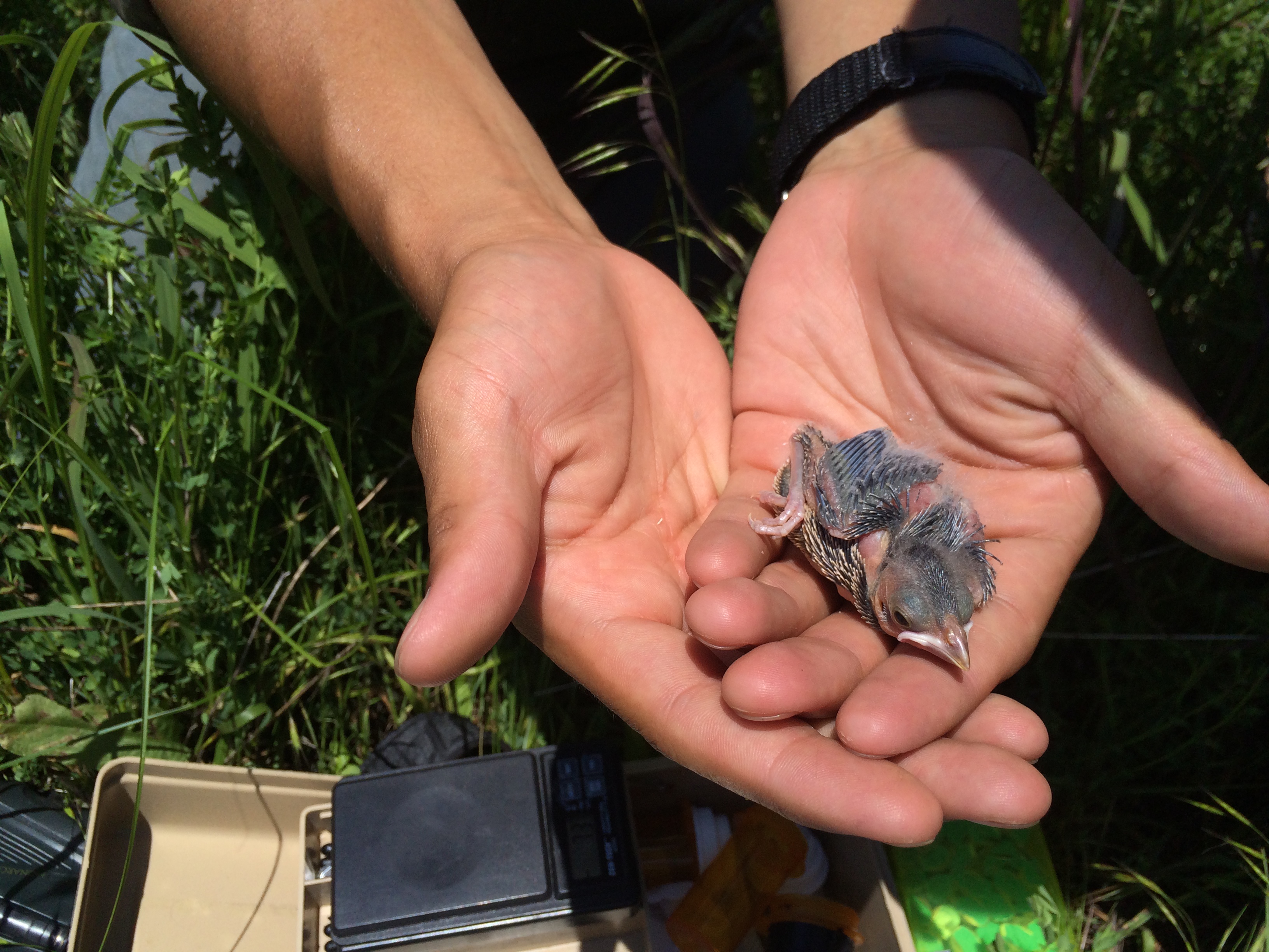
Nest Sampling: To find nests, we will use behavioral cues from male and female birds. I will search all pastures every 1-4 days, especially targeting areas where there is evidence of female activity (Martin and Geupel 1993). These activities include carrying nesting material, intermittent foraging, and delivering food to nestlings (Jensen and Cully Jr 2005; Sousa and Westneat 2013). After nests are found, we will take the GPS coordinates of the nest location and place flagging 5 m to the north and south to aid in relocation. Flagging will be placed approximately 10-20 cm from the ground to avoid cuing predators. We will monitor nests every 1-3 days, visiting more frequently when nestlings near fledging. Nestlings will be weighed and have their tarsus measured on day 5 or 6 to avoid force fledging (Schadd and Ritchison 1998).
To measure provisioning rates at nest sites, we will use video monitoring methods (Mitchell et al. 2012). Using camcorders, we will record nestling provisioning activity at each nest with nestlings during calm weather, with no rain or wind>10 mph to avoid damaging the camera (Samsung High Definition HMX-90). Recording will take place between days 3 and 7 post hatching to avoid nest abandonment or premature fledging (Schadd and Ritchison 1998). The camcorders on tripods will be placed at least 1 m from nests, with recording starting between 05:45-08:00 and lasting approximately four hours. Each nest will be filmed twice two days in a row to determine if parents alter their provisioning behavior after having acclimated to the camera’s presence. If a nest cannot be sampled twice (i.e., equipment shortages due to number of active nests, inclement weather), a decoy tripod will be set up at the nest site for 24 hours prior to filming to allow the birds to acclimate to the camera’s presence. Footage will be uploaded to video processing software, and provisioning behavior by male and female birds will be subsequently quantified in the lab. If possible, the identity of the prey item will be recorded to taxonomic order (Mitchell et al. 2012). Based on preliminary data from footage collected in 2015, identifying to order should be possible in most provisioning instances.
Figure 4. Research footage of a female dickcissel feeding nestlings (Coon, unpublished data)
Vegetation Sampling Near the Nest: To assess relationships between tall fescue, arthropods, and nesting birds, we will quantify the relationships between vegetation composition and arthropod abundance within a nest buffer. We will measure vegetation at either end of 50 m transects to ensure we will remain within territory boundaries. Following the Daubenmire method previously described (Daubenmire 1959) (Vegetation Sampling), we will measure the structure and composition of nest vegetation in 0.5 m2 quadrats in the four cardinal directions. These quadrats will be randomly placed 1-5 m from the nest. To ensure that vegetation measurements reflect the territory as a whole, we will also measure the structure and composition of vegetation at four fixed points at the ends of the 50-m transects, (or extending 25 m from the nest in the four cardinal directions).
Arthropod Collection Near the Nest: To sample the arthropods near the nest, we will use a vacuum and sweep net as previously described. We will sample using the vacuum and net to either side of a 50-m arthropod transect. Each transect’s central point will be at the nest, beginning randomly from one of eight cardinal or intercardinal directions. If the transect crosses a boundary such as a road or a fence, a second direction will be randomly selected. To avoid oversampling, we will subsample 2 m out of every 5 m. This is a total of 11 sampling points, with 22 m sampled for every 50 m transect.
Quail surveys: To monitor quail in the spring, we use a whistling count which captures the number of male quails calling. There is a systematic grid with points spaced every half mile on study sites. We begin surveying these points at sunrise and spend five minutes at each point counting the number of quail we hear at each point. The whistling count method approximate the quail occupancy on study sites. We can then compare the quail occupancy with that of other species of interest. This method originates from recommendations from the Iowa Department of Natural Resources.
Other Methods
Point process theory: For our research about grassland bird community nest placement, a spatial data set is a nest network organized into nodes and links. Each node is the geographic coordinates of a nest and the links are the distances between the nearest neighboring nests. One nest network represents one layer. Layers can also be maps of habitat features (i.e. fragmentation, size and shape of patch) or node attributes (i.e. nest success or failure, time).
Landowner survey: We will administer mailback surveys to all landowners with >8 ha of land in the GRG, who will be identified with county directories. I will use a multiple contact system and reminders for non-respondents (Dillman et al. 2014). First, participants will be sent a postcard that says “Survey Coming!” with brief information about the purpose of the study. After two weeks, participants will be sent a paper copy of the survey with a cover letter. Participants will be given the option to complete an electronic survey using the online survey platform Qualtrics (Dillman et al. 2014). After two more weeks, non-respondents will be sent reminder letters. Lastly, after another two-week interval, the survey will be re-sent to nonrespondents. This process will begin in February 2017 and continue for eight weeks. The project will be identified as a collaborative project between Iowa State University and the University of Illinois on all correspondence.
Based on information from previous work, the approximate population of landowners in the GRG is 300 individuals. The 2007 survey had an acceptable 51% response rate, and we will use several techniques to increase this further. First, having an electronic survey will provide participants with a convenient option to complete the survey. Other small steps, such as using brown envelopes and blue ink, personally signing correspondences, and individually stamping letters, will also increase response rate (Dillman et al. 2014).
Sections of the previous survey will be replicated for comparison, including questions on livelihoods, biodiversity, and demographic information. Likert scales will be developed to measure attitudes toward invasive species management practices (herbicide and fire), personal and community norms associated with these management practices, and perceived ability to perform these behaviors. We will use scale items from both the previous study and other published studies with few adjustments whenever possible(Ajzen 1991; Prinbeck et al. 2011). Before beginning, we will obtain all necessary permissions regarding the use of human subjects from the University of Illinois Institutional Review Board.
References:
Ajzen, I. (1991). The theory of planned behavior. Organizational behavior and human decision processes 50:179-211.
Bibby, C. J. (2000). Bird census techniques. Elsevier.
Buffington, M., and R. Redak (1998). A comparison of vacuum sampling versus sweep-netting for arthropod biodiversity measurements in California coastal sage scrub. Journal of insect conservation 2:99-106.
Daubenmire, R. (1959). A canopy-coverage method of vegetational analysis. Northwest Science 33:43-64.
Dillman, D. A., J. D. Smyth, and L. M. Christian (2014). Internet, phone, mail, and mixed-mode surveys: the tailored design method. John Wiley & Sons.
Jensen, W. E., and J. F. Cully Jr (2005). Density-dependent habitat selection by brown-headed cowbirds (Molothrus ater) in tallgrass prairie. Oecologia 142:136-149.
Martin, T. E., and G. R. Geupel (1993). Nest-Monitoring Plots: Methods for Locating Nests and Monitoring Success (Métodos para localizar nidos y monitorear el éxito de estos). Journal of Field Ornithology:507-519.
McIntyre, N. E., and T. R. Thompson (2003). A Comparison of Conservation Reserve Program Habitat Plantings with Respect to Arthropod Prey for Grassland Birds. The American midland naturalist 150:291-301.
Mitchell, K. L., S. K. Riffell, L. W. Burger Jr, and F. J. Vilella (2012). Provisioning of nestling dickcissels in native warm-season grass field buffers. The Wilson Journal of Ornithology 124:298-309.
Pillsbury, F. C., J. R. Miller, D. M. Debinski, and D. M. Engle (2011). Another tool in the toolbox? Using fire and grazing to promote bird diversity in highly fragmented landscapes. Ecosphere 2:28.
Prinbeck, G., D. Lach, and S. Chan (2011). Exploring stakeholders’ attitudes and beliefs regarding behaviors that prevent the spread of invasive species. Environmental Education Research 17:341-352.
Robel, R., J. Briggs, A. Dayton, and L. Hulbert (1970). Relationships between visual obstruction measurements and weight of grassland vegetation. Journal of Range Management:295-297.
Schadd, C. A., and G. Ritchison (1998). Provisioning of nestlings by male and female Yellow-breasted Chats. The Wilson Bulletin:398-402.
Sousa, B. F., and D. F. Westneat (2013). Variance in mating success does not produce strong sexual selection in a polygynous songbird. Behavioral Ecology 24:1381-1389.
Stewart, A. J., and A. F. Wright (1995). A new inexpensive suction apparatus for sampling arthropods in grassland. Ecological Entomology 20:98-102.
Wilson, S., J. Smith, and A. Purcell III (1993). An inexpensive vacuum collector for insect sampling. Entomological news.
Protocols
This project has not yet shared any protocols.