About This Project
Unprecedented wildfires from escaped slash-and-burn farming and/or unsustainable hunting methods are promoting rapid habitat loss in a historically heavily forested area where target at-risk species have a remaining stronghold. We aim to address the blindspots in data regarding at-risk species populations and forest canopy cover (Green et al. 2005). Findings will be communicated through a series of sustainable-farming and anti-poaching campaigns.
Ask the Scientists
Join The DiscussionWhat is the context of this research?
With the onset of the Covid-19 pandemic, agricultural operations have expanded rapidly as subsistence farmers are desperate to obtain food security and maintain their livelihoods. As a result, deforestation in the Selva Maya of Belize has exploded and threatens key at-risk species and the overall biodiversity of the area. Subsistence farmers are open to alternatives to slash-and-burn but require education and tools to implement change. Illegal hunting and poaching occur in large part because hunters are unaware of hunting seasons. This only exacerbates the problem.
What is the significance of this project?
Slash-and-burn agriculture is one of the main factors causing habitat degradation in the tropics (IUCN 2021). We are hopeful that this pilot program can be replicated worldwide where slash and burn agriculture is extensively used. We believe that by providing alternative sustainable methods as well as creating an environmental consciousness, we will have a lasting impact on our community and their future generations.
What are the goals of the project?
We will target local subsistence farmers (min. 15) for training on alternative farming methods and provision of materials. Other landowners and village youth (min. 75) will be targeted for hunting/poaching campaigns and engaged in surveying, monitoring and habitat creation. We expect wildfires and hunting to decrease as farmers and hunters adopt a sustainable mentality towards resource use. We expect populations of listed species to recover and this will be measured by presence on remote cameras, and canopy cover will be restored and measured through aerial drone surveying.
Budget
We will map the location and boundaries of targeted agricultural land areas through GIS mapping and aerial drone imagery. We will then compare canopy cover and boundary lines from the initial project start date over the course of the five fire seasons during project duration to previous records of fire seasons documented by the Belize Forestry Department.
Endorsed by
 Project Timeline
Our project will occur over a 5-year time-frame but the first research phase will be initiated before the peak of this dry season which begins in April. The first phase of the work is to map the surrounding farmland, both the T.R.E.E.S farm and our community's farms, so that we have base-line data with which we can monitor our efforts over time. In order to do this we need to create high resolution imagery since it is not currently available. From here we can produce ArcGIS Maps.
Mar 31, 2021
Taking aerial footage by flying drone over T.R.E.E.S and community farms
Apr 09, 2021
Create a detailed map of the T.R.E.E.S property and delineate orchards, gardens, and natural habitats
Apr 20, 2021
Project Launched
Apr 30, 2021
Create a detailed map of the community farms that clearly delineates agriculture from forest to use as a baseline to measure forest cover loss over time.
Meet the Team
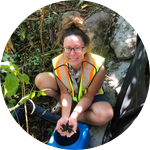
Vanessa Kilburn
For the past 15 years, Vanessa Kilburn has been active in the field of conservation biology with a focus on herpetology both in North America and in Central America. Throughout her career she has gained extensive experience in field methodology techniques used for fish, amphibians, reptiles, birds, and mammals. Vanessa has designed and conducted habitat assessments and habitat characterization work in various temperate and tropical habitats, in particular wetlands, lakes, and streams. Prior to moving to Belize and establishing T.R.E.E.S and its field station, she lead Endangered species recovery programs in British Columbia and in the Dominican Republic, which included scientific research, hands-on habitat restoration, and public outreach and education. As a result of these efforts Vanessa has gained experience working with all levels of government, non-government organizations, the private sector, industry, academia, and the general public. She holds a B.Sc. Honours in biology from the University of New Brunswick and an M.Sc. in conservation biology from McGill University. She is currently the Program Manager for T.R.E.E.S and is responsible for designing the activities and programs offered at the center, in addition to conducting her own research on herpetofauna in the Maya Mountains.
Lab Notes
Nothing posted yet.
Project Backers
- 5Backers
- 20%Funded
- $200Total Donations
- $40.00Average Donation