Please wait...
About This Project
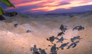
Our goal is to measure the effect of coastal light pollution on hatchling loggerhead ability to find the ocean. We hypothesize that there will be a threshold intensity above which hatchlings become disoriented and less efficient at "sea finding".
Artificial light is a pollutant which is increasing in U.S. urban environments at a rate of 6% per year. Determining hatchling response to various light levels will be important to the long term conservation strategies for endangered sea turtle species.

Browse Other Projects on Experiment
Related Projects
Satellite tracking the secret lives of vulnerable juvenile Loggerhead sea turtles off Morocco’s Coast
This pioneer project marks the first time in Morocco's history for satellite transmitters deployed on sea...
Out for blood: Hemoparasites in white-tailed deer from the Shenandoah Valley in Northern Virginia
Our research question centers about the prevalence and diversity of hemoparasites that infect ungulate poplulations...
Cyanova: A modular, budget photobioreactor for the efficient cultivation of microalgae
Microalgae are overlooked constantly as a protein source because of it's high costs and complex maintenance...