Please wait...
About This Project
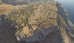
If an archaeologist could have one super power- it would be X-RAY vision. Archaeologists are always looking for non-destructive techniques to see what lies beneath the surface. This project will use the newest in UAV'S (Unmanned Aerial Vehicles) as well as Infrared (Thermal) and Near Infrared cameras to create high resolution maps of the Early Iron Age site of Zagora, Greece. The final product will hopefully be the creation of several high-resolution multispectral 3D models of the site.

Browse Other Projects on Experiment
Related Projects
Y-DNA A00 and the Peoples of Cameroon: In Search of the Homeland
This was the first phase of our fundraising campaign to support our fieldwork in Cameroon. We were very...
Excavation of El Toril Cave to delve into the evolution in the Pleistocene of the Iberian Peninsula
The Iberian Peninsula is rich in Pleistocene fossils, but there is a fossil hiatus at the Lower Iberian...
Which of Cameroon's peoples have members of haplogroup A00?
We're now aiming for a higher $9000 Stretch Goal in Round Two of our fundraising, for our groundbreaking...