


Please wait...
About This Project
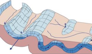
In the Alps, there are karst areas where plentiful precipitation soaks right in. This water flows through underground passages to important springs in the valleys below. Except for a few caves, these groundwater conduits are un-mapped. We are testing remote sensing methods for locating them. This will aid land use and water withdrawal planning to protect this critical resource from threats posed by (e.g.) increased development and climate change.

Browse Other Projects on Experiment
Related Projects
Worms at Work: Scoping Natural Carbon Sequestration at Scale
For centuries, scientists noted earthworms' exploits as ecosystem engineers. Recent research shows the feasibility...
Whales as oceanographers: Developing multi-sensor tags for improved understanding and management of critical habitats
Limited oceanographic data prevent accurate prediction of whale foraging hotspots. To address this, we will...
Communities perception and monitoring of ocean acidification in the Douala-Edea national park (Cameroon)
This project will help us to evaluate the vulnerability of clam fishing to ocean acidification (OA) in the...