


Please wait...
About This Project
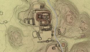
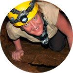
Aerial LiDAR surveys have been popular tools for mapping ancient Maya settlements through the dense rainforest canopy. LiDAR mapping at El Pilar revealed several previously unknown large structures, but many smaller structures in low, swampy areas were invisible to this technique. This project will develop a program of field-checking LiDAR anomalies to clarify the patterns of small structures in seasonal swamps, where settlement models predict people would not live.
More Lab Notes From This Project

Browse Other Projects on Experiment
Related Projects
Unlocking the origins of horse-humans interactions: Radiocarbon dating of ancient horse bits
Horses transformed human history, and horse control technologies evolved over centuries, as demonstrated...
Using community science to evaluate the intersection of social, racial, and economic injustices in North Birmingham, AL
Environmental injustices differentially impact low wealth communities of color, and this pattern of inequity...
How are rural communities on the edge of the largest tropical peat swamp forest in the Congo Basin using peat resources?
Climate change and human interference threaten to degrade the world’s largest tropical peatland. No detailed...