Methods
Summary
This is a samples collection project that will feed a subsequent samples analysis & results reporting project. Three specific areas of the the Kikkar (Hebrew word for the "plain" of the Jordan in Genesis) will be investigated, as shown in this figure:
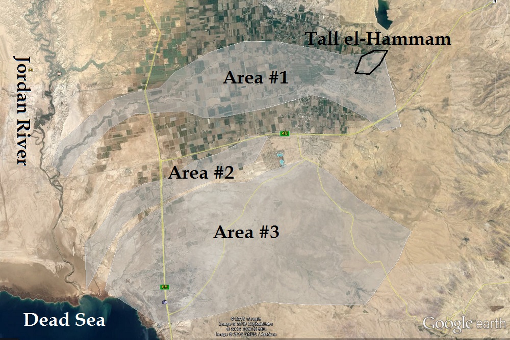
Area #1 includes the wadi that cuts the valley floor from the west end of Tall el-Hammam to the Jordan River; Area #2 includes the wadi that passes by Teleilat Ghassul; and Area #3 includes the wadis that come down from the plateau to the east of the Dead Sea and run along the base of the rise. These areas will be explored in succession as time and funding permit. The wadis in these three areas will be traversed by foot to provide a careful examination of the strata. Collaborating researchers in the USA will examine multi spectral satellite imagery of Area #3 to identify the sites that might provide a high probability of producing usable samples.
The hope is to find strata of ashy loam that are similar to the destruction layers already examined at and near Tall el-Hammam. The best candidate strata will contain ancient pottery sherds that provide information to date the strata. Representative samples of the sherds will be collected along with soil samples from above, within, and below the stratum of interest.
The collected samples will be screened to separate fine (< 1 mm), medium (1-5 mm), and coarse (> 5 mm) materials. The coarse materials will be examined visually to separate out individual pieces that exhibit evidence of high-temperature exposure. These pieces will be kept, and the rest will be discarded. Approximately 1/2 kg of the medium material will be double-bagged as is. A super magnet will be used to separate magnetic particles from the fine material. The magnetic particles will be kept, and the rest will be discarded. The saved material will be tagged with the GPS coordinates of the collection site and shipped back to collaborating researchers in the USA for analysis.
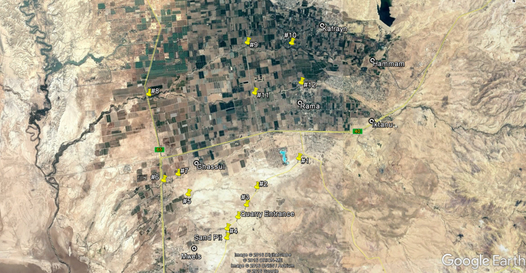
Update 12/10/2017 -- Here is a map that I put together on Google Earth showing the target entry points to the wadis under investigation...
Challenges
The greatest challenge to the success of this project is finding suitable strata from which to collect samples. During the recent (February 2016) dig season of the Tall el-Hammam Excavation Project (TeHEP), 5 members of this project team (including myself) walked approximately 1 km west of Tall el-Hammam through the deep dry wadi before we found the first candidate strata. Good hiking boots, plenty of water, and sharp eyes are an absolute necessity.
The second significant challenge is the fact that these wadis traverse private property, most of which is agricultural. Fortunately, I have made good contacts during the past 5 years as a field archaeologist with TeHEP, and I have already recruited a few who are willing to assist me as drivers/interpreters to help me negotiate access from the landowners.
Pre Analysis Plan
Five years of personal familiarity with the terrain and people of the area, plus additional satellite imagery reconnaissance, set the stage for conducting this samples collection effort. Satellite imagery reconnaissance by other members of the research team is proceeding at this very moment.
During the later analysis phase, Scanning Electron Microscopy (SEM), chemical and elemental analysis, and other methods will be used to examine the collected samples. Preliminary analysis of the materials I collected for my doctoral dissertation revealed high-temperature melt products such as the melted zirconium crystals and spherules of other melted material shown in the images, below.
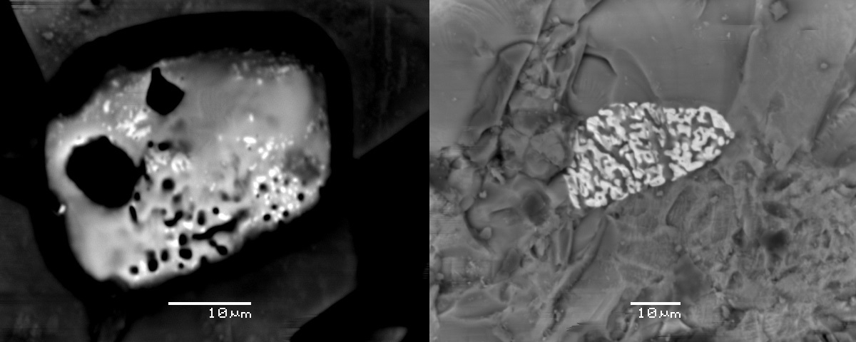
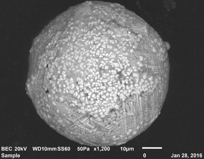
These are but two of the known proxies of cosmic airburst events that we seek through this research project.
Protocols
This project has not yet shared any protocols.