Hugh Thomas

Hugh Thomas

Jan 22, 2017

Group 6 Copy 2,948
1
Please wait...

About This Project

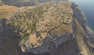
If an archaeologist could have one super power- it would be X-RAY vision. Archaeologists are always looking for non-destructive techniques to see what lies beneath the surface. This project will use the newest in UAV'S (Unmanned Aerial Vehicles) as well as Infrared (Thermal) and Near Infrared cameras to create high resolution maps of the Early Iron Age site of Zagora, Greece. The final product will hopefully be the creation of several high-resolution multispectral 3D models of the site.


Blast off!

Browse Other Projects on Experiment

Related Projects

Where are the Spanish Colonial Jesuit Missions at Guevavi?

Guevavi was a major focus of missionization efforts among the Sobaipuri-O'odham. We think we have identified...

Fanteca Project: Student-led study of opiates and overdose in NYC

To address overdoses in NYC, it is important to know how many people are at risk, how many have had non...

Kumeyaay landscapes, knowledge transfer, and land stewardship in San Diego

The goal of this project is to leverage indigenous knowledge with geographic information systems (GIS) and...

Backer Badge Funded

An anthropology project funded by 60 people