
Please wait...
About This Project
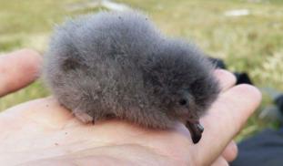
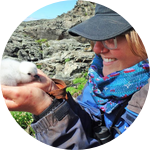
Discovering where seabirds fly while they're at sea is notoriously difficult, because we can't observe them directly. We aim to rectify this by tagging and tracking one species, the elusive and diminutive European Storm Petrel, on its forays off the Atlantic coast of Ireland. We will use this information to build a map showing when and where the species forages, ultimately enabling us to protect them from oil spills, wind turbines and other dangers at sea.

Browse Other Projects on Experiment
Related Projects
Satellite tracking the secret lives of vulnerable juvenile Loggerhead sea turtles off Morocco’s Coast
This pioneer project marks the first time in Morocco's history for satellite transmitters deployed on sea...
Out for blood: Hemoparasites in white-tailed deer from the Shenandoah Valley in Northern Virginia
Our research question centers about the prevalence and diversity of hemoparasites that infect ungulate poplulations...
Cyanova: A modular, budget photobioreactor for the efficient cultivation of microalgae
Microalgae are overlooked constantly as a protein source because of it's high costs and complex maintenance...
.JPG&width=650&height=&caption=Experiment.com+-+Crowdfunding+for+Science+Research)