Methods
Summary
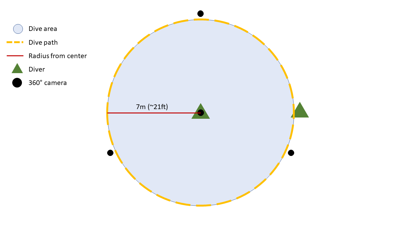
A visual survey will be used to create rapid estimates of relative abundances and species identification over shallow water reef communities. The specific visual survey method planned for this project is the point-count method. The study site will have a stationary center point of reference and coral will be identified and recorded in a radial fashion around the center point, creating a circular study site (see Figure 1). A minimum of two divers will be used in collecting data at each site. A primary diver at the center will have one end of a marked 7m long tape measure and a 360° camera recording video for collecting supplemental data, including; permanent record of diving conditions, fish, invertebrates, and benthic environmental conditions. The primary diver will be tasked with recording reef-building corals to at least genus (e.g. Acropora and Porities) and growth type. A secondary diver will take the other end of the 7m tape measure and define the edge of the survey site. To do so, the secondary diver will swim in a circle maintaining the 7m radius as the primary diver remains in the center of the survey area. The 7m radius creates a survey site of approximately 150m2. After the primary diver has identified all the coral, damage and disease, he/she will trade places with the secondary diver and swim along the edge of the survey area allowing the primary diver access to the entire survey area and all coral within the 150m2 survey site.
Challenges
Conducting research underwater comes with a large set of challenges. Limited oxygen and communication during SCUBA as well as environmental factors ( e.g., water clarity, waves, currents and daily weather) will play a role in the success of this project. We have already tested out the cameras on dry-land and gone though how and where to put the 360° cameras in relation to the dive area. The next step however involves practice in a local dive pool to identify potential issues within a controlled environment. This will allow us to work on time management and communication while diving. Additional challenges will include accurate identification of coral species and relative abundances of disease and invasive species. In-situ identification will be supplemented with the 360° video and close up photos.
Pre Analysis Plan
The research aim is to evaluate the abundance of coral species present, the general health of the community and the extent of invasive species.
Abundance estimates for all coral will be classified into 1 of 5 groups recorded. Abundance estimates will be classified into five groups: Rare (one individual seen), Uncommon (<25% coverage), Common (50% coverage), Abundant (>75% coverage) or Dominant (90-100% coverage). (DeVantier & Turak, 2017).
Descriptive statistics generated from notes taken in-situ and viewing of the 360° footage will substantiate conclusions regarding the research hypothesis.
Protocols
This project has not yet shared any protocols.