


Please wait...
About This Project
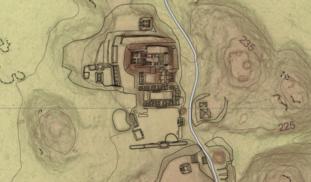
Aerial LiDAR surveys have been popular tools for mapping ancient Maya settlements through the dense rainforest canopy. LiDAR mapping at El Pilar revealed several previously unknown large structures, but many smaller structures in low, swampy areas were invisible to this technique. This project will develop a program of field-checking LiDAR anomalies to clarify the patterns of small structures in seasonal swamps, where settlement models predict people would not live.
More Lab Notes From This Project

Browse Other Projects on Experiment
Related Projects
To Selfie or Not to Selfie - How Can Scientists Foster Public Trust on Instagram?
U.S. adults see scientists as intelligent, but not always warm. This is a problem because people's perceptions...

How Can Tattoo Artists Help Prevent Human Trafficking?
Women who are sex trafficked often have tattoos such as bar codes, a dollar sign or the name of their trafficker...

Are prejudiced reactions to same-sex couples characterized by specific physiological patterns?
What makes some people react to the sight of two men holding hands with anger, hatred & violence...
